
Turkington Falls Natural Area
- Ownership
- Town of Redding and The Nature Conservancy
- Acreage
- 65.34
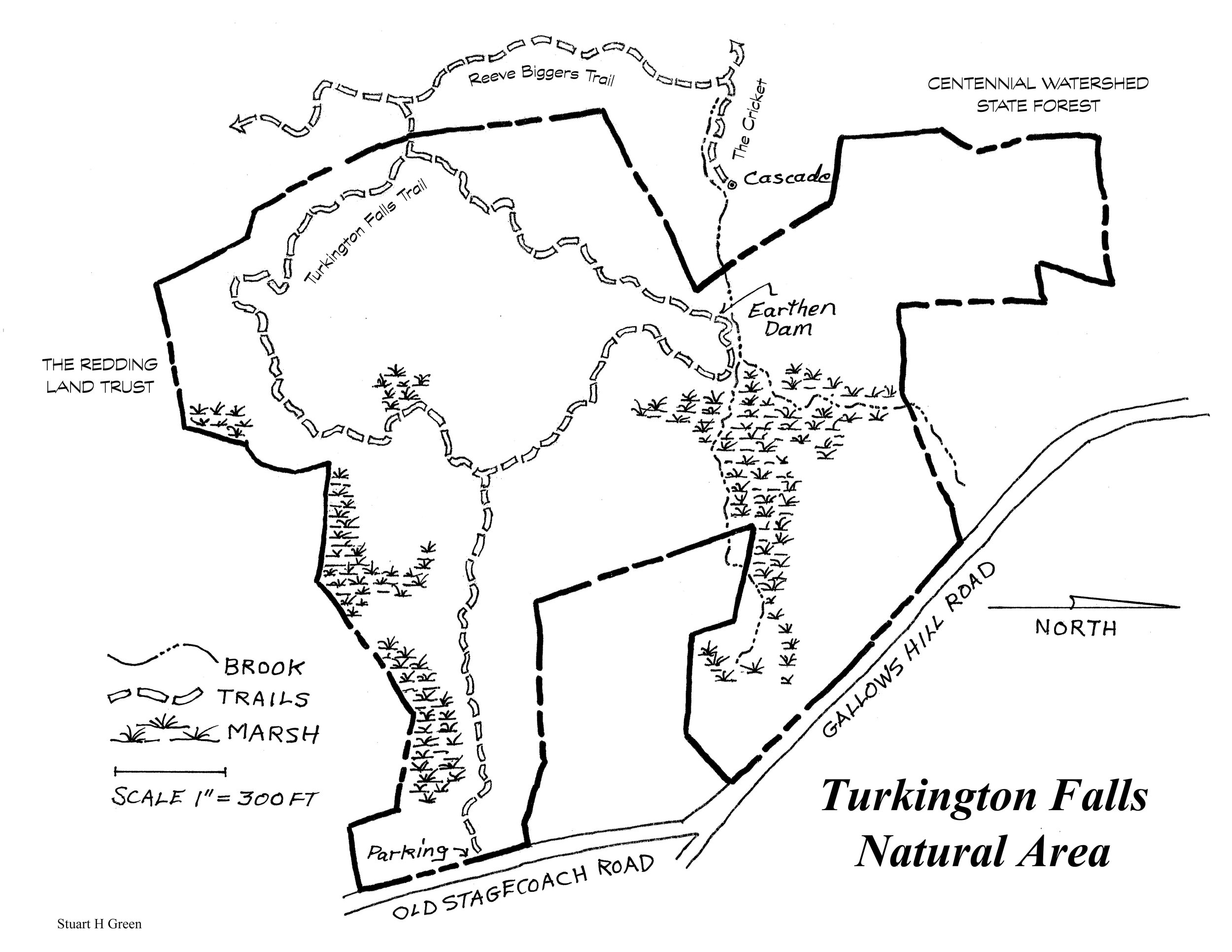
- Entrance
- West side of Old Stagecoach Road 1/10th of a mile south of Gallows Hill Rd.
- Parking
- Limited on shoulder of road at Entrance
- Trails
- Turkington Falls Loop, 1.1 white
Link to Reeve Biggers trail, 0.04, blue
Total all trails: 1.14 - Trail App
- Turkington Falls Loop
Background: Formerly known as the Krueger/Jarkow property, the Turkington Falls Natural Area was acquired by the Town of Redding and the Nature Conservancy with substantial financial assistance from the CT Department of Environmental Protection in 2001. The 1984 Redding Open Space Plan had identified the need to preserve a Saugatuck River Greenway to maintain large areas of natural habitats, biotic diversity and the protection of water quality. With 132 acres of permanent watershed owned by Aquarion Water Company to the west and the Redding Land Trusts 14.5 acre McMurray gift (1988) to the south the projected greenway included the Krueger property.
In 2003 the property was renamed after an Irish immigrant, Oliver Turkington, who moved to this country after his marriage. (He was disinherited by his father who was greatly displeased by the match.) Oliver settled in Redding and took up weaving as a business. By 1860 he was assessed for three dwellings, 109 acres of land, one horse and ten cattle.
The trail was designed and cut by Trail Tenders Stuart Green and Kent Blocher and Mark Mainieri of the Nature Conservancy.
Key Features: The 65 acre tract contains a mix of hardwoods and red cedar typical of old field succession. Described by Stuart A. Reeve, Ph.D., in his 1999 Archeological Survey, an unnamed stream flows south into a large wetland and then tumbles through a spectacular gorge to join Tannery Brook and the Saugatuck River. There are many rock ledges and outcroppings, and the land is crossed by stone walls, remnants of historic agriculture.
From Old Stagecoach Rd the trail skirts a large wetland to meet the junction with the larger loop. Proceeding north through a stand of yellow poplar the trail soon winds down to the beginning of the gorge marked by the remnants of an old earthen dam. In addition to this historic landscape feature there are several areas of prehistoric archeological sensitivity in the natural area.
The trail climbs away from the gorge and eventually traces a ridge to a junction with a short link to the Reeve Biggers trail. The loop continues back to the access way crossing an interesting spine of ledge along the way.
But where are the falls? The question was answered by Bruce Given who had explored the gorge downstream where the water spills in such a lovely flume that someone installed an Adirondack style bench at an ideal and contemplative viewpoint. This overlook is now accessed from a spur from the Reeve Biggers trail known as The Cricket. ❧